
The community is always part of the response.
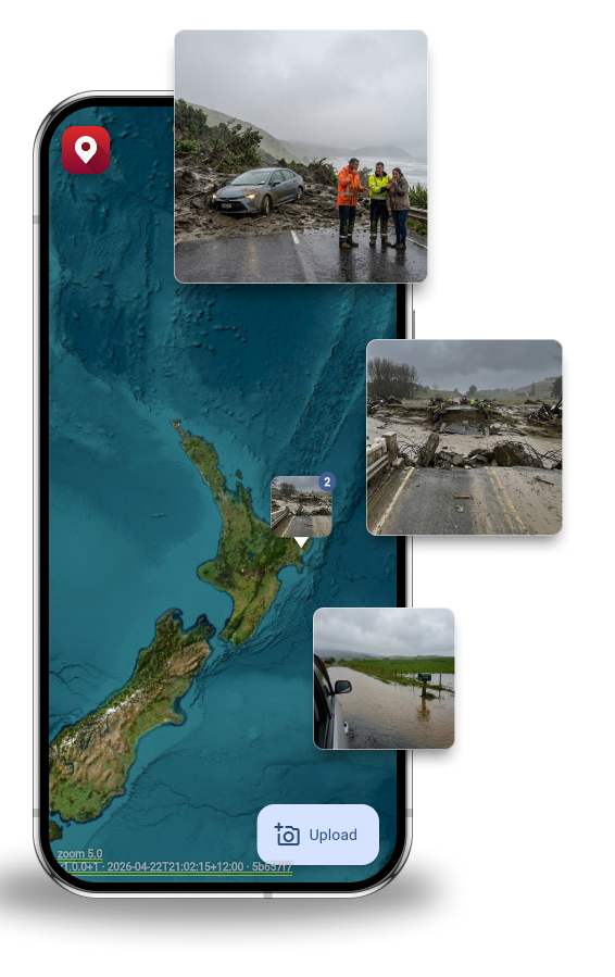
When an event hits, your community is out there before your field teams are. GeoMarqr gives them a way to contribute important information, even when the towers are down.
For Civil Defence & Emergency Management
Community volunteers, Neighbourhood Support networks, Locals, they're already out there when disaster strikes. GeoMarqr gives them a friction-free way to Marq what they're seeing. No account, no training required.
“After Cyclone Gabrielle, a coronial inquest confirmed what operators already knew. New Zealand had no centralised platform for sharing ground-level information during an emergency.
This came 14 years after the issue was identified during the Christchurch earthquake. GeoMarqr was built to be the solution.”
What your EOC gets
-
Community eyes before your field teams arrive
In the first minutes of an event, community members are already in affected areas. GeoMarqr turns their phones into a reporting layer, with no training, no account, and no barrier.
-
Accurate location under poor conditions
Offline-first means the pin is accurate even when towers are down. The photo is geotagged at capture, not upload. The moment connectivity returns, the image is uploaded, whether that's five minutes or five hours later.
-
Hot-zone detection for EOC controllers
Pro tier delivers date-range filtering and area activity reports. See where damage is clustering before your field teams have arrived. Prioritise deployment based on where reports are coming in.
-
The 4Rs, supported by the community you've built
Readiness, Reduction, Response, Recovery. GeoMarqr sits across all four. Community access before an event, reporting during, evidence for recovery funding after.

Designed for the connectivity blackout.
Most major events in New Zealand have been followed by a connectivity blackout. Towers go down, lines get cut, coverage disappears in exactly the areas where you need it most. GeoMarqr was built for this. No connection is required to capture and Marq a report.
- Offline capture with accurate GPS pin
- Uploads from original location when signal returns
- No account or login required
- Works through power outages
The report is made when the situation is captured, not when connectivity comes back.
Plans
Create an account to manage your uploads.
Individual
Anonymous
No account. No barrier. Just the photo.
- Anonymous upload
- AI tags & filters
- 5-day auto-delete
- Offline-first upload
- No ads
- Manage your images
- Date-range filtering
- Hot zone detection
Free Account
Keep track of your uploads across devices.
- Anonymous upload
- AI tags & filters
- 5-day auto-delete
- Offline-first upload
- Manage your images
- Save custom filters
- No ads
- Date-range filtering
- Hot zone detection
Pro $9 NZD/mo
For curious explorers, motorhome travellers, and anyone who wants more — and wants to keep the lights on.
- Everything in Free Account
- No ads
- Date-range filtering
- Hot zone detection
- Area activity reports
- Supports the network
Team & Enterprise
Team $30 NZD/seat/mo
Private workspace for your crew. Send clients a link to upload their own photos — straight into your team.
- Everything in Pro
- Private team workspace
- Controlled photo visibility
- 100 client upload links/seat/mo
- Client uploads stay in your team
- Inspector-ready sharing
Enterprise
For councils, not-for-profits, research institutions, and innovation teams doing important work.
- Everything in Team
- No ads
- RapidMiner / Mendix integration
- Data science API access
- Custom data exports
- Dedicated support
- Education & not-for-profit pricing
Get in Touch
Tell us about your organisation and what you're building. We'll get back to you shortly.
[ Contact form goes here — e.g. Tally, Typeform, or similar ]
Privacy
- No account required to upload
- Auto-deletes after five days — nothing stored permanently
- Geotagged at point of capture, not point of upload
- Anonymous by default
In an emergency, the community doesn't wait to be activated.
Give them a tool that works when nothing else does.
Talk to Us About CDEM Integration