The data your community is already generating.
Every photo Marqed to the map is a structured data point — location, timestamp, AI-tagged category. At scale, that's a spatial intelligence layer your models have never had access to before.
Talk to Us About Data Access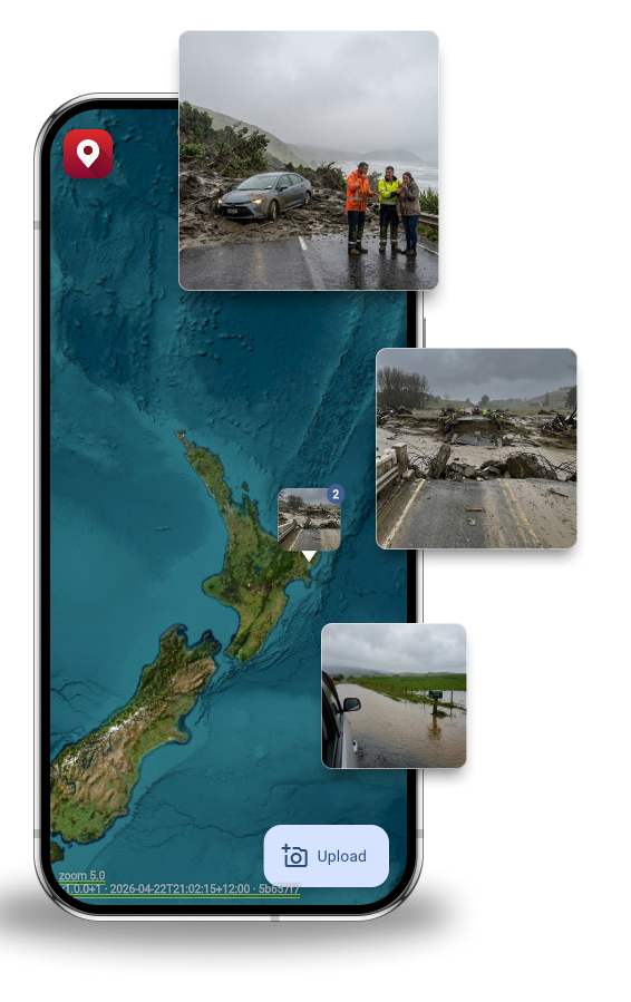
For Data Analysts at Councils and Waka Kotahi
GeoMarqr's community reporting layer produces structured, geotagged, timestamped data at a density no survey team can match. LowCode NZ — same founding team, Siemens partner — connects that data directly to RapidMiner for the analysis your team actually needs.
After Cyclone Gabrielle, Gisborne District Council documented 5,200 road faults across 2,238km of local roads — by hand, with cameras and clipboards. The data existed. It just wasn't structured, timestamped, or queryable. GeoMarqr was built to fix that at the point of capture.
What the data layer gives you
-
Hot zone detection
Where are reports clustering? Which intersections, which road types, which weather conditions? GeoMarqr's density analysis surfaces the patterns before they become incidents — or before the next funding round needs justification.
-
Date-range filtering for event analysis
Query every report within a defined area and time window. Before and after a weather event. Pre- and post-maintenance. The data is timestamped at capture, not upload — so the record is accurate even when towers were down.
-
RapidMiner integration via LowCode NZ
LowCode NZ — Siemens partner, same founding team as GeoMarqr — connects your data to RapidMiner for predictive modelling, asset failure analysis, and CAT event risk scoring. Your community reporting layer feeding your enterprise analytics platform.
-
Corridor-level pattern analysis
Which routes generate recurring reports? Which asset types keep appearing? GeoMarqr's spatial data connects to your existing infrastructure records for the cross-reference your maintenance planning has been missing.

Accurate data from the field. Even without coverage.
Community members and field surveyors capture in dead zones — GeoMarqr stores the GPS coordinates at the moment of capture and uploads from that location when connectivity returns. The data your models receive is accurate to the point of observation, not the point of upload.
- GPS timestamped at capture
- Accurate through connectivity blackouts
- AI-tagged on upload — no manual categorisation
- Queryable by location, date, and category
Eyes on site are invaluable. GeoMarqr makes sure those eyes count.
Plans
Support the network and get more out of it — $9 NZD/month.
Individual
Anonymous
No account. No barrier. Just the photo.
- Anonymous upload
- AI tags & filters
- 5-day auto-delete
- Offline-first upload
- No ads
- Manage your images
- Date-range filtering
- Hot zone detection
Free Account
Keep track of your uploads across devices.
- Anonymous upload
- AI tags & filters
- 5-day auto-delete
- Offline-first upload
- Manage your images
- Save custom filters
- No ads
- Date-range filtering
- Hot zone detection
Pro $9 NZD/mo
For curious explorers, motorhome travellers, and anyone who wants more — and wants to keep the lights on.
- Everything in Free Account
- No ads
- Date-range filtering
- Hot zone detection
- Area activity reports
- Supports the network
Team & Enterprise
Team $30 NZD/seat/mo
Private workspace for your crew. Send clients a link to upload their own photos — straight into your team.
- Everything in Pro
- Private team workspace
- Controlled photo visibility
- 100 client upload links/seat/mo
- Client uploads stay in your team
- Inspector-ready sharing
Enterprise
For councils, not-for-profits, research institutions, and innovation teams doing important work.
- Everything in Team
- No ads
- RapidMiner / Mendix integration
- Data science API access
- Custom data exports
- Dedicated support
- Education & not-for-profit pricing
Get in Touch
Tell us about your organisation and what you're building. We'll get back to you shortly.
[ Contact form goes here — e.g. Tally, Typeform, or similar ]
Privacy
- No account required to upload
- Auto-deletes after five days — nothing stored permanently
- Geotagged at point of capture, not point of upload
- Anonymous by default
Your community generates more infrastructure data than your survey teams ever could.
Talk to us about connecting it to your analytics platform.
Talk to Us About Data Access