Forged in NZ
Snap it.
Pin it.
Five days.
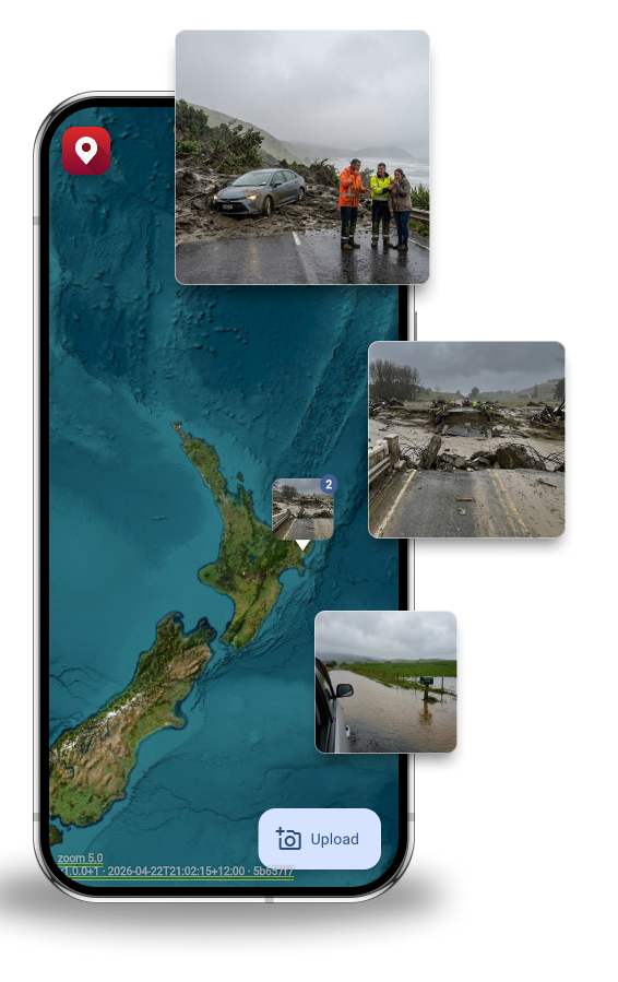
Your image geotagged on a live map. Works offline. No account needed. Auto-deleted in five days.
Free on iOS & Android · No account required to upload
Why GeoMarqr exists
In early 2023, Cyclone Gabrielle cut through the East Coast of the North Island of New Zealand. Roads were gone. Power was out. Phone and Internet services were lost. Emergency crews struggled to co-ordinate. Community members could see what was happening — but had no way to communicate it.
GeoMarqr was built because nothing else existed that could capture a geotagged photo in a dead zone and share it to a live map when signal returned. It takes ten seconds. No account. No training. No barrier.
"Built by Kiwis, for Kiwis after the cyclone. Coz nothing like it existed."
How it works
- 1
Take the photo where you are
No signal needed. GeoMarqr captures your exact location the moment you take the photo — not where you reconnected. The pin is always right.
- 2
AI tags it and it goes on the map
Automatic categorisation and filters. The photo is geotagged to where it was taken. No description needed — just the photo.
- 3
Gone in five days
Nothing is stored permanently. The report stays live long enough to matter, then disappears. No account required to upload.

The pin is always accurate
Most apps geotag from wherever you upload. GeoMarqr captures your location at the moment you take the photo, so even if you drove two hours to find signal, the pinned location is of where you snapped the image.
- Offline-first — no coverage required to capture
- AI tagging — no description needed
- Auto-deletes after five days
- Free tier requires no account at all
Built for who?
One traveller Marqs a landslide. The next travellers can reroute before they reach it. Emergency crews send the right response to the right location. Councils build accurate infrastructure history. Everyone wins from a single photo.
On the Road
- Motorhome & Caravan
You're first out there. Report what you see before the next traveller hits it.
See how it works → - Visitors to NZ
NZ roads are genuinely different. A community reporting layer helps you travel safer.
See how it works → - Road Trippers & Truckies
Out of reception half the time. Works offline — tagged at the original photo location.
See how it works → - Car Rental Companies
Every tourist gets a map. Give them a way to report what they see.
See how it works →
Field & Recovery
Emergency & Govt
- Civil Defence
Community volunteers are already out there in the first hours. Use GeoMarqr to find exact locations.
See how it works → - NZ Police
Your community is already out there. GeoMarqr gives them a frictionless way to report.
See how it works → - Waka Kotahi NZTA
Community hazard reports. Real-time road visibility.
See how it works → - Local Councils
Residents report infrastructure damage, geotagged and timestamped. No training needed.
See how it works → - Analytics
Structured, geotagged, timestamped data at a density no survey team can match.
See how it works →
Built for when things aren't working.
No reception on site? Power out? Cell towers down? GeoMarqr holds the photo until you're back in range, then uploads from the original location. The pin is always accurate — whether you reconnected five minutes later or drove two hours to get signal.
- Works through power outages
- Works in dead zones
- Accurate location tagging
Download GeoMarqr
Free on iOS and Android. Upload without an account. The photo is gone in five days but the people who need to know, will know.
No account required to upload · Free forever on the basic tier